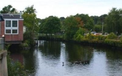
Pawcatuck River Fishing Spot
- Elevation: 8'
- Last Modified By: vinny60 on 09/06/09 05:00 PM
- Ask about Pawcatuck River in our Fishing Forums
Photos
Fish Species
Comments
-
Have you fished at Pawcatuck River? Be the first to comment on this fishing spot.
Pawcatuck River Baits and Tackle
Live Bait (Other) Check Prices
- deadly dick
- eel
In-Line Spinner Check Prices
- spearing/sqid
Hard Swimbait Check Prices
- yo zurry
Worm Check Prices
- red tube sandworm
Roundhead Jig Check Prices
- 4oz buck tail with a strip of squid and live mummy chub.
a 14inch non weighted trailer with a yellow skirt & live mummy
Saltwater Jig Check Prices
- gulp shrimp
- on the teaser
Saltwater Spoon Check Prices
- deadly dick
Pawcatuck River Description
The Pawcatuck River is a river in the U.S. states of Rhode Island and Connecticut flowing approximately 48 km (30 mi). There are eight dams along the river's length. The Pawcatuck River's source is Worden Pond in South Kingstown. It proceeds roughly southeast through the villages of Kenyon, Carolina, and Bradford. It then turns briefly northwest and west before resuming a southwarward course to flow past Potter Hill and between the towns of Westerly, Rhode Island and Pawcatuck, Connecticut until it finally empties into Little Narragansett Bay on Long Island Sound. The Pawcatuck River and its estuary create a natural border between portions of southern Connecticut and Rhode Island. The glacially formed Pawcatuck River watershed spans an area of 317 square miles—260 square miles in Rhode Island and 57 square miles in Connecticut. This watershed is Rhode Island’s largest, draining nearly one third of the state. It stretches approximately 23 miles north to south, 20 miles east to west, and discharges an average of 675 cubic feet per second of freshwater into the estuary at Westerly, R.I. The Usquepaug, Wood, and Ashaway rivers are the major tributaries of the Pawcatuck. The freshwater drainage basin runs through rural uplands, woodlands, forests, and small towns that were once thriving mill villages. While scattered industries can be found along the river, large industrial complexes are somewhat isolated from its banks. In the estuary (the saltwater portion of the watershed), rural land use gives way to the urban center of Pawcatuck-Westerly, R.I. Industry is historically more common in this section of the watershed, due to the proximity of the ocean and overland shipping to New York, Providence, and Boston. Little Narragansett Bay, at the southern extent of the watershed, is shallow and provides protected waters for recreational boaters and a barrier beach at Napatree Point that is used extensively by summer beach-goers. Little Narragansett Bay also provides a high-quality ecological habitat for a variety of birds, fishes, invertebrates, marine plants, and occasional marine mammals, such as harbor seals.
The Pawcatuck River is a river in the U.S. states of Rhode Island and Connecticut flowing approximately 48 km (30 mi). There are eight dams along the river's length.[1]